

Alpe-Adria-Trail: Hiking from the Alps to the sea with a stopover in Villach
The Alpe-Adria-Trail is one of the most famous long-distance hiking trails in Europe. It runs for around 750 kilometers from the foot of the Grossglockner to the Italian port town of Muggia near Trieste, passing through Austria, Slovenia and Italy. The route connects landscapes and cultures that share a long common history and consistently follows the water. From the glacial ice of the Hohe Tauern, it passes numerous waterfalls, lakes and rivers all the way to the Adriatic Sea.
If you don’t want to walk the entire trail, you can choose individual stages, as each stage is designed as an independent day hike. Villach is the central station in the middle of the route and is an ideal starting point or stopover.
Accommodation on the Alpe-Adria-Trail in Villach
If you are hiking the Alpe-Adria-Trail and are planning an overnight stay in Villach, the Boutique Hotel Goldenes Lamm offers centrally located accommodation in Villach city center. The accommodation is within walking distance of the main points of interest in the city and is therefore practical for hikers who don’t want to walk any further after a long stage.
The Golden Lamb is suitable both as a stopover on the way south and as a starting point for the rest of the trail.
Our advantages for hikers
The Goldene Lamm is geared to the needs of hikers and offers practical services for a pleasant stay.
- Flexible length of stay: bookings are possible from as little as one night. Ideal for individual stage planning.
- Early breakfast: An early breakfast is available for hikers who want to start early. This allows you to start the day’s stage in good time.
- Shuttle service and luggage transport: We are happy to help you organize the official shuttle service and luggage transport to your next accommodation.
Alpe-Adria-Trail in Villach
One of the central stage towns on the Alpe-Adria-Trail is Villach in Carinthia. The town marks an important point on the route from the Alps towards the Adriatic and invites you to pause for a moment and enjoy the route so far.
Villach offers everything hikers need for a relaxing break: a lively city center, good restaurants and a pleasant atmosphere that makes your stay more than just a stopover. If you plan to spend a night here, you will start the next section of the trail the next morning feeling rested and motivated.
Stages of the Alpe-Adria-Trail
The Alpe-Adria-Trail stretches for around 750 kilometers. The stages are between around 12 and 27 kilometers long and take between four and a half and eight and a half hours, depending on the section and walking speed.
- Austria (E01 to E21): The Austrian section comprises 21 stages and is the longest part of the trail. It starts at the Kaiser-Franz-Josefs-Höhe at 2,367 meters and leads through the Hohe Tauern National Park, the Nockberge Biosphere Park and along the large Carinthian lakes: Millstätter See, Ossiacher See and Wörthersee. The section ends at the border with Slovenia.
- Slovenia (E22 to E27): Six stages lead through Slovenia. The route leads through the Triglav National Park and the Soča Valley, among other places.
- Italy (E28 to E37): The last ten stages lead through the Friuli-Venezia Giulia region, past the cultural town of Cividale del Friuli, through the Collio wine-growing region and the karst landscape north of Trieste to the destination of Muggia on the Adriatic.
- Three-country circular hiking trail (R1 to R7): In addition to the main trail, there is a seven-stage circular hiking trail around the border triangle of Austria, Slovenia and Italy. This leads from Lake Faak via Warmbad Villach, Nötsch, Tarvisio and Kranjska Gora back to the starting point.
Map
An interactive map with all the stages is available on the official website of the Alpe-Adria-Trail. In addition, the entire GPS route of the trail can be downloaded free of charge as a GPX file. For local navigation, we also recommend the official Alpe-Adria-Trail app, which bundles stage data, refreshment stops and up-to-date information.
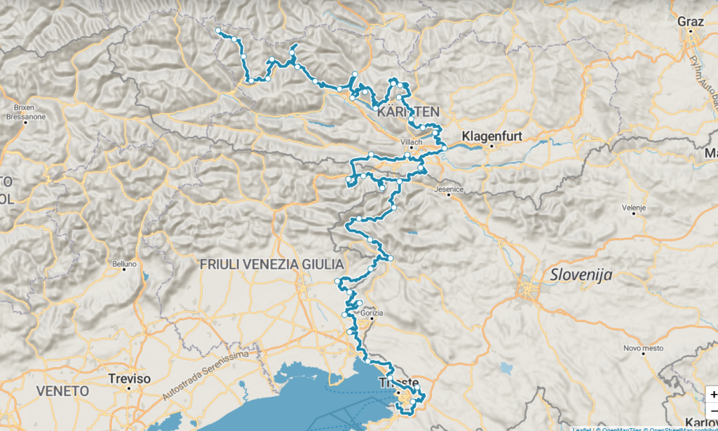
Alpe-Adria-Trail map with all stages © alpe-adria-trail.com
Tips for your hike on the Alpe-Adria-Trail
Anyone planning the Alpe-Adria-Trail should clarify a few practical points in advance. The following tips provide an initial overview of the most important preparation steps.
Best time of year
The hiking season on the Alpe-Adria-Trail runs from May to October. If you want to walk all stages safely, including the first high mountain stage, it is best to plan from June, as the higher altitudes are reliably snow-free at this time.
Stage planning
The trail does not have to be hiked in one piece. Many hikers divide the route into one-week sections and return for their next vacation. Each stage can be walked independently and is signposted in both directions, which makes individual planning much easier.
Condition and preparation
You should be prepared for daily hiking times of up to eight and a half hours and ascents and descents of up to 1,500 meters in altitude. A certain basic level of fitness and well-worn, waterproof trekking or hiking boots are recommended.
Organization
If you don’t want to do the planning yourself, you can book a fully organized hiking tour via the Alpe-Adria-Trail booking center. The package includes accommodation bookings in certified partner businesses, luggage transportation, a shuttle service and a trail hotline for en route.
Equipment and luggage
The most important piece of equipment for the Alpe-Adria-Trail are well-worn, waterproof trekking or hiking boots with a non-slip sole. They ensure sure-footedness on changing surfaces and protect your feet on long daily stages.
When it comes to clothing, several thin, functional layers can be flexibly adapted to changing weather conditions. A windproof and waterproof outer layer and suitable sun protection should not be missing on any stage.
The basic equipment also includes a first aid kit, sufficient fluids and food as well as a charged cell phone.
FAQs about the Alpe-Adria-Trail
How long does it take to complete the Alpe-Adria-Trail?
If you walk the entire trail in one go, you should allow around six to seven weeks. However, most hikers complete the trail in several parts and choose individual sections.
Can I hike the Alpe-Adria-Trail as a beginner?
The Alpe-Adria-Trail is also suitable for beginners. For the most part, it runs through non-alpine terrain, there are no exposed passages or sections secured by ropes and the signposting is clear throughout. If you have little experience, it is best to choose shorter stages and allow sufficient time.
How difficult is the Alpe-Adria-Trail?
Technically, the trail can be classified as easy to medium. There are no exposed or rope-insured passages. However, individual stages are quite demanding in terms of fitness, taking up to eight and a half hours and covering up to 1,500 meters in altitude.
When is the best time for the Alpe-Adria-Trail?
The trail is accessible from May to October. For the Austrian high mountain section, we recommend starting in June, when the paths are reliably free of snow.
Where can you find accommodation on the Alpe-Adria-Trail?
Accommodation can be searched for and booked directly via the Alpe-Adria-Trail website. Those planning an overnight stay in Villach will find centrally located accommodation at the Boutique Hotel Goldenes Lamm.
Is the Alpe-Adria-Trail suitable for families with children?
Basically yes, but the suitability depends heavily on the chosen stage. The trail runs mostly in non-alpine areas and offers many shorter, easily accessible sections. It is important to choose the stages carefully and to realistically estimate your daily performance.
How does the arrival and departure to the Alpe-Adria-Trail work?
The Alpe-Adria-Trail is easily accessible both by train and by plane. Suitable train stations include Mallnitz, Villach, Velden as well as Cormòns and Trieste in the Italian section. The ideal travel option depends on the chosen starting point for the trail.